
Some Thoughts on Castle Varrich, Tongue. (by George Watson)
27th December 2014
This article appeared in the Caithness Field Club Bulletin for 2013.
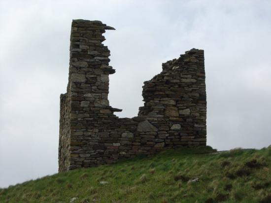
Perched on a rocky hilltop overlooking the Kyle of Tongue this small tower was described in 1791 as, "a structure so antient, that there is no consistent tradition concerning it"i. Subsequent years have had little to add, forcing visitors to speculate on its origin and history. Those searching for information are restricted to a few sentences in the Statistical Accounts, and the remains of the building itself. A plan of the building, published by MacGibbon and Ross in 1889 ii, shows a doorway in the south wall of the upper floor, but this is contradicted in the attached notes, which correctly place the doorway in the east wall.
The Building :- The tower has been two storeys high, with vaulting over the lower chamber, while the cruck slots in the north and south walls indicate a roof construction similar to that of a traditional cottage. Its walls are of red sandstone laid in regular rubble courses broken here and there by blocks of Moine schist. Lime mortar generously laced with seashells can be seen in some exposed wall sections. Externally the structure measures 7.5 m (24ft-6in) along the south wall and 6.7m (22 ft) along the other three sides. The wall is 1.7 m (5ft-3in) thick except in the NW corner where it is reduced to 1.4m (4ft-6in) iii. There is now no sign of harling on the outside but traces of plaster can be found inside.
On the ground floor, remnants of vaulting have been reduced to neatly trimmed ledges inside the north and south walls. Window apertures are no longer apparent though the published plan shows one in the east wall and it seems likely that there was another in the north wall,which was later enlarged to become the present entrance. The outer face of the wall surrounding this doorway has a large area of re-built stonework, with the irregular joint clearly visible within the thickness of the wall on both sides of the doorway. The original access to the vault is no longer apparent but it is worth noting that a similar arrangement at Brims, in Caithness, has a trap-door in the floor of the upper room and a very narrow intramural stair.iv.
On the upper storey there are now substantial gaps in the east, west and south walls. However, the original entrance to the tower can still be traced on this floor from fragments of door lintel and door sill embedded in the east wall. It is also clear that there has never been an opening in the north wall where a complete set of cruck slots shows that the inner face of this wall has not been modified. From the dimensions of the cruck slots, it can be seen that the roof timbers were not heavy enough to support a high roof and therefore the suggestion that there was at one time another upper storey can be discounted.
For a ruin with gaping voids in three of its four walls there are surprisingly few loose stones scattered outside; this contrasts sharply with the debris inside. It would appear that between 1841 (NSA) and 1889 (published plan) the site had been tidied-up by trimming the rough edges of the vault, patching the wall at the NW corner, and opening an entrance on the ground floor to make a romantic ruin for Victorian visitors.
Its Function? :- One of the most difficult aspects presented by the building is its function. It has many of the defensive features of a small tower house; thick walls, a first floor entrance and vaulting as a barrier against fire. However the thatch roof, implied from its cruck supports, would have been a considerable fire risk, so perhaps a slated roof should not be ruled out.
Despite its lofty location, the view from inside would have been restricted. To the south it is blocked by rising ground, while coverage towards the ferry and the open sea must have been limited by the absence of an upper window in the north wall. Clearly the building was not designed as an watch tower. The strongest clue to its use is the allocation of space inside. This is evenly divided between living accommodation on the upper floor with a storage vault of similar size underneath. Had a building of this description been located on the shore near a recognised landing place, it would have been identified immediately as a defensible storehouse, for rents or teinds paid in kind. Because of their strength, such storehouses were often precursors of later castles; as illustrated in the early phases of the castles of Brims and Mey, in Caithness
Although difficult to prove, it is possible that this storehouse at Tongue was deliberately placed on the hilltop as a landmark for travellers crossing the trackless expanse of the Moine moor, where a road was not built until 1830.
The Placename :- The structure of the building cannot provide a precise date, its small size and the absence of gun ports suggests that it could be early, but the use of lime mortar, cruck roof supports and the presence of vaulting, would indicate that it is not early enough to be Norse. Never-the-less a Norse origin for the tower is still canvassed, on the premise that the modern placename Varrich can be identified with Beruvik, mentioned in the Orkneyinga Saga.
The earliest c1034 describes Kali Hundason sailing north from Beruvik into the east end of the Pentland Firth. Wherever this place was, it was not on the north coast to the west of the Firth and therefore cannot be Castle Varrich.
The next reference c1150 applies quite definitely to Berwick-on-Tweed, in Northumberland and is also irrelevant to Castle Varrich.
The final mention c1153 when Earl Rognvald was attending his daughter's wedding in Sutherland and "rode from Beruvik to Thorsa". This Beruvik could be anywhere in Sutherland within riding distance of Thurso. The creek at Berriedale in southern Caithness not only satisfies this description as fully as Castle Varrich but would also answer the 1034 descriptionv. To add to this vagueness James Gray corrected the translation of the relevant phrase "from Beruvik" to "from the bridal (brudkaupi)"vi.
Just to connect the saga Beruvik with the modern placename Varrich stretches credulity to its limit. This fragile link must surely snap if the placename evidence is further extended to pinpoint a building which has no uniquely Norse characteristics. Consequently the saga is unhelpful in dating the existing structure.
Timothy Pont's maps, sketched in the 1580s, confirm the presence of a building on the hilltop. He gives two versions of the name, Doun Varrich and Dun Vorrich; no doubt his phonetic rendering of local Gaelic, which he did not speak vii. Dun has a range of meanings from a heap through mound, hillock, hill, to fortified place viii so we have no way of knowing whether Pont intended the place name for the hill, the building, or both.
A hint that Varrich was first applied to the hill can be taken from a snippet of traditional history preserved in the Old Statistical Account [1791], which recounts that, " there is a cave in the rock upon which the castle is built, called Leabuidh Eoin Abaruich , ie John of Lochaber's Bed, whither he is said to have retired in times of danger."ix John's by-name, Abaruich could well be the origin of Pont's Varrich.
The author of the OSA, knew the tower on the hilltop, as Caistal a Bharruich, and went on to suggest that it might have been possessed by John Abrach. But this is a step too far, the similarity between a Bharruich and Abaruich could have arisen if John gave his name to the hill top, from which it transferred to a later building. The folktale of John Abrach's Bed is useful however for he is an historical figure who took part in the battle of Druim na Coup (c1431) and died c 1450x. He is unlikely to have slept in a cave if a safer bed was available in the tower, and there would be little point in building a tower which was less secure than the cave. This sets the earliest possible date for the construction of the tower in the second quarter of the 15th century, although it could, of course, be later. It certainly existed in the later part of the 16th century when Pont surveyed the area.
Sir Robert Gordon, who may have visited Tonguexi, is the first person to call the tower a castle when he noted "In Strathnaver ther are tuo castles Borwe and Toung." Toung can be identified as Castle Varrich for Sir Robert continued, "Macky his speciall residence is at Toung, one myle from the place wher the castle doth stand."xii This ‘speciall residence' also appears on Pont's map, in the neighbourhood of Tongue House.
The Anglification of the placename to Castle Varrich was complete by 1841xiii, when it was said to signify ‘the castle on the eminence'. This interpretation has been accepted and now appears on modern maps, re-translated as Caisteal Bharraich.
History of the Locality :- Having emerged from the battle of Druim na Coup with the upper hand the Mackays carried the struggle into Sutherland and Caithness, leaving the area around Castle Varrich in relative peace for many years.
Consequently, to our loss, the circumstances surrounding the tower’s origin and subsequent use went unrecorded.
Following the destruction of Mackay’s castle at Borve in 1554, a new house was built on the low ground near the ferry on the east side of the Kyle of Tongue.xiv A miniature drawing, on Pont’s map, shows a square tower(?) flanked by two wings or smaller buildings. There is now no trace of this building which was destroyed late in 1654 either by Cromwell’s troops or more probably by Mackay himself to deny it to the enemy.xv. For the next 24 years the chief’s main residence was at Durness, and it was only when Tongue House was rebuilt 1678 that it once again became his headquarters.xvi It is surely significant that although the destruction of Borve Castle and the first house at Tongue are well attested, history is silent on the status of Castle Varrich during these violent episodes.
Its Ownership :- Like most of its history, the ownership of Castle Varrich must remain doubtful. Lying deep in clan lands, it would not be unreasonable to expect it to belong to the Mackays. However it was not mentioned during the campaign which destroyed Mackay’s castle at Borve,which could indicate that its owner was neutral at that time. The Bishop of Caithness who was the feudal
20
superior of lands in this region is a likely candidate and it has been suggested, that the tower was owned and used by him when travelling between Scrabster and Durness xvii. The unconventional location of this store may not have been ideal for a rest-house with a steep climb to be faced at the end of each tiring journey but it would have provided travellers with a prominent landmark.
The Bishop in a charter dated 7th July 1540, reserved to himself and his successors the nearby lands of Rigaboll (Ribigill) which eventually became the glebe for Kintail.xviii. Even though the Reformation of the church in Caithness and Sutherland was overseen by Bishop Robert Stewart, it still involved the loss of church land, which would have made a tithe-store such as Castle Varrich redundant. Without regular maintenance, natural decay could have rendered the building uninhabitable by the Cromwellian period and therefore not worthy of mention when the first Tongue House was destroyed in 1654.
Summary :- Consideration of the placename and the architectural evidence indicates that Castle Varrich is unlikely to be earlier than the second quarter of the 15th century. Despite its unusual location on the hill top the design of the building is that of a storehouse. The fact that Castle Varrich was not involved in any of the many clan disputes suggests that it was not a Mackay property. This leaves the Bishop of Caithness as the most likely owner although positive evidence is lacking. Any connection between Castle Varrich and the diocese would have been broken at, or within a few decades of, the Reformation in 1560 and it is likely that the building fell out of use about this time.
Tailpiece :- Visitors to Castle Varrich have regularly commented on the roof cruck slots in the north and south walls. They indicate a cottage type roof, probably thatched which was unusual in a two storey building. As stated above Castle Varrich was probably out of use by Cromwellian times, but later, after the Restoration, a similar building was constructed on Harris by Sir Norman MacLeod of Bernera. A rather scathing couplet describing it has been translated:-
"Tower, calling a house a tower, When it has only couples and beams."xix
i Statistical Account of Scotland, 1979 reprint, Vol XVlll, Tongue Parish, page 476
ii Castellated &Domestic Architecture of Scotland, MacGibbon & Ross Vol lll, reprint1990 page 254.
iii RCAHS, Canmore record card,Caisteal Bharraich.
iv RCAHS, Inventory of Monuments etc in the County of Caithness, page 114, No 424.
v The Orkneyinga Saga, ed J Anderson, 1073, pages 18 & 165.
vi Sutherland and Caithness in Saga-Time, James Gray, 1922, pages 69 &148.
vii The Pont Manuscript Maps of Scotland, J C Stone, 1989, pages 20 & 22.
viii Dwelly’s Illustrated Gaelic to English Dictionary, 1977.
ix Statistical Account of Scotland, 1979 reprint, Vol XVlll, Tongue Parish, page 476
x Sutherland and the Reay Country, Rev A Gunn & J Mackay, 1897, pages 23,33
xi Chief of Mackay, Ian Grimble, 1965, page 127.
xii The Earldom of Sutherland, Sir Robert Gordon, 1813, page 11.
xiii Second Statistical Account of Sutherland, Tongue Parish, 1841, page 175.
xiv Chief of Mackay, Ian Grimble, 1965, page 42.
xv Chief of Mackay, Ian Grimble, 1965, page 168.
xvi Sutherland An Illustrated Architectural Guide, E Beaton, 1995, page 87.
xvii Castellated & Domestic Architecture of Scotland, MacGibbon & Ross Vol lll, reprint1990 page 254.
xviii The Book of Mackay, A Mackay, 1906, page 89.
xix Highland Folk Ways, IF Grant, 1961,page 154.
See Photos of a Walk to Castle Varrich on 18 May 2005 at -
http://www.caithness.org/atoz/sutherland/photogallery/index.php?gallery=39&start=0
Related Organisations
Related Articles
Caithness Field Club Winter programme 2019 - 20 February - April
Saturday 22nd February: A walk led by Sharon Pottinger around her patch. It's about 6 miles, mainly on by-roads, so bring a pack lunch.Caithness Field Club Bulletin 2018
Caithness Field Club Bulletin 2018 Articles now added at the link above Caithness Field Club Summer Programme 2018 - See below Field Club Activities during 2017 (by Tony Bradford) Botanical Report 2017 (by Francis and Margaret Higgins) Ranger Wildlife Notes 2017 (by Paul Castle) Strathmore Flora (contributed by Keith Gerry) Allan's Reminiscences (by Allan Abernethy) Place-names - Nottingham and Snottergill Burn (by George Watson) St Donnan - Patron Saint (by Audrey Munro) Thusater Dig (by Caithness Broch Project) Caithness Field Club Trips (by Anna Rogalski) Heads of Heroes (by Geoff Leet) Tale of a Carriage (by Tony Bradford).Hetty Munro's War Diaries by Elizabeth Rintoul - July 1942 - February 1943
First published in the Caithness Field Club Bulletin 2010 Vol 7 No 6. The following extracts from the War Diary of the late Henrietta Munro of Thurso come from the North Highland Archive and are published with their permission.Hetty Munros War Diaries by Elizabeth Rintoul
Hetty Munros War Diaries by Elizabeth Rintoul First published in the Caithness Field Club Bulletin 2011 Vol 7 No7. The following extracts from the War Diary of the late Henrietta Munro of Thurso come from the North Highland Archive and are published with their permission.History of Cabrelli‘s Cafe at the Camps in Wick by Lyndall Leet
This article was first published in the Caithness Field Club Bulletin 2010 Vol 7 No 6. Early in the 20th century, Italian-owned cafes, ice cream parlours and chip shops spread through- out Scotland, run by enterprising immigrants, who saw Scotland as a land of opportunity, at a time when work was scarce in their own country.
Caithness Field Club Winter programme 2018 - 19
Thursday 29th November at 7:30pm: A talk by Roy Mackenzie on the Veteran's Tower, in the Smith Room at the Pulteney Centre, Huddart Street, Wick Tuesday 22nd January 2019 at 7:30pm in the Pentland Hotel, Thurso: A talk by Lydia Fensome on bygone bikes, illustrated by some in her own collection. Saturday 9th February 2019: A walk, led by Joy and Tony, around Achvarasdal, to see the broch.Caithness Field Club - Events March to May 2018
Caithness Field Club Winter programme 2018. Tuesday 20th March at 7-30pm: A talk Iain MacLean of Caithness Broch Builders Project on latest findings: in Pentland Hotel, Thurso.CAITHNESS FIELD CLUB PROGRAMME 2016-17
Sunday 2 October 2016 Walk for Highland Archaeology Festival Seeking hut circles using Li. Dar images - Geoff Leet to lead.Hidden Landscapes: LiDAR survey of a multi-period landscape in Caithness
Hidden Landscapes: LiDAR survey of a multi-period landscape in Caithness (by Charlotte Douglas, Graeme Cavers & Andy Heald). From the Caithness Field Club Bulletin 2014 Caithness is well known for its spectacular archaeology but aerial laser scanning surveys carried out in the county have revealed glimpses of the hidden archaeological landscapes that are less easily appreciated.
An Unusual Door Support (by Geoff Leet)
Published in the Caithness Field Club Bulletin Vol 8 No. 1 - April 2013 An Unusual Door Support (by Geoff Leet) At Nottingham Mains farm, close to the Doocot at the Wag of Forse (ND212355) is a barn, probably built as a piggery.
Search Our Site
Information
What's On
Submissions